Tuesday, October 28, 2008

Desert of Maine: October 9th, 2008

For my 5th cite visit, I went to the Desert of Maine. Thinking I could go and walk around the desert FOR FREE I went there thinking I would have an awesome experience. Instead I had to pay 10 DOLLARS but I still had an awesome experience.
Myself and Ashley were the only ones there besides the workers. With the end of the season for the desert coming just around the corner, I could understand why they made me pay 10 DOLLARS. It was a nice day outside, fairly warm and the sand was dry. At first, we walked into the gift shop, looked around and then proceeded out the back to walk into the desert. When inside the desert, you are allowed to freely walk around and explore. We first checked out the barn and looked at all the neat artifacts.Next we went into the desert. I hadn't been there since I was a kid and being older I could appreciate it much more. I had never seen anything like this before in my life.
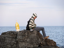
The sand looked like actually desert sand but there were bright green trees around the perimeter of the desert. There was also running water along the sides of the sand and I also found a mushroom growing in the middle of the desert. Besides walking the trails, there wasn't much else to do in the desert. In order to keep you entertained, the workers put up neat signs around the desert that had cool facts about the place. So Ashley and I walked around looking at all the signs, but after walking around for about 45 minutes we called it quits and left. However before we left, I had to get a picture of the camel and its little baby. Historical Significance
The Desert of Maine, is the only desert found in Maine and is formed naturally. The desert of Maine is 40 acres of glaciers sand, located in the middle of the woods in Freeport, Maine. Before the desert became a desert, it was a farm land. The farm land was owned by the Tuttle family. Mr. Tuttle, a wealthy man from Boston, moved to Freeport to start a farm and try is hand at farm work. They purchased the land in 1797. After years of not rotating the crops and overgrazing by animals, the land started to turn up glacier sand. Eventually the sand would overcome 40 acres of the Tuttle's land and in 1919, they abandoned the land. In the same year, Henry Goldrup purchased the land for 300 dollars and in 1925 made it into a tourist attraction.
The workers that work there are always learning reasons why the sand appeared on the land. What the workers have come to find out, through universities and archaeologists, that the land actually sits on a lake bed. They believe that the land was sucked up by the lake, forming the sand that is there now. The sand rose so high that in some places of the desert, the sand rises more than 100 feet. If you walk to the edges of the desert you can see just how high the sand is. However, even though there is plenty of sand, vegetation is starting to take back the land. Grass and trees are starting to grow on the sand, hinting that the land might turn fruitful once more. If you look closely at the sand, you can see that the sand isn't really real desert sand but glacier sand that freezes in mid-winter.
Over the years the Desert of Maine has been subject to many scholars. Archaeologists have come from all over to study the land in the desert and many tourists come to see this phenomenon. The Desert of Maine is significant to Maine because Maine is the only state in New England that has a so called "desert." It adds to the economy of Maine by leading tourists to Maine, plus it adds to the history of Maine. For once this isn't an example of preservation because the land was specifically bought for the purpose of leading tourists to this cite. However, the money that is made goes towards the preservation of the 300 year old barn sitting next to the gift shop. So I guess that this is an example of preservation in a small way. (Maine is all about preservation) Hopefully the Desert of Maine sticks around Maine for many years to come but it looks like mother nature might want her beloved land back.
Resources: The Desert of Maine workers, Wikipedia

Monday, October 27, 2008

Thorncrag Bird Sanctuary, September 24th 2008

Living only a half a mile from Thorncrag Bird Sanctuary, it only took me two minutes to get there by car. I decided to go there the day after Peeks Island because I was in an "get homework done" mood and the weather was very warm that day. So wearing shorts and t-shirt, Ashley (my fiancee) and I made our way into the trails of the Sanctuary. We have been here many times before but not since the recent construction of the new parking lot and revamping of the trails. We usually take the red trail but today we decided to take the white and blue trails with the intention of ending up at the grand fireplace.
With the weather getting cold, the sanctuary was surprisingly green and full of life. We saw many birds, squirrels, and bees, but we managed to avoid ticks. Along the way we came across many ponds but there is a fairly large pond with benches at it. Also along the trails are plaques, such as the one above. I had Ashley take a picture of me in front of a pond, as proof that I was there.
We sat at many of the benches along the way, to rest and take pictures. When we got to the fireplace, Ashley and I had a picnic. After eating we made videos of us dancing, and doing silly things. After about an hour we made our way down the green trail back towards the car. We didn't stay long, because the polish man that I am, wore shorts in late September. Although the weather was warm when we arrived, it was cold by the time that we left.
Historical Significance
Thornscrag is a tourist attraction but not as much as Old Orchard, or Lewiston. Really, Thornscrag is primarily used as a place for locals to find peace from the world. It is a quiet place where locals can walk their dogs, run, walk, or have a picnic. This is what Ashley and I did. Thornscrag isn't only a free nature trail, but a bird sanctuary. There are a few birds that dwell within Thornscrag that are not found in the entire state of Maine.
Thornscrag was originally home of Elder Thorn as farmland and eventually belonging to the Highland Spring Water Bottle Company. Thornscrag would become a 357 acre wildlife preserve. Surrounding it are the suburban and commercial life of Lewiston. The fire place that sits upon the "Crag" is the highest point in Lewiston. Thornscrag has been a bird and wildlife sanctuary for more than 80 years.
This place is significant because it represents the community that it resides in. All forms of people come to visit this place and it houses sanctuary for many people. Also many activities for certain groups, such as the boy/girls scouts and Bates College, are held at Thornscrag. Again, we see another sign of preservation in Maine life. As a whole we see the local peoples outreach towards a attempt to preserve the life around them.

Wednesday, October 22, 2008

Battery Steel: Wednesday September 23, 2008


On Wednesday September 23, 2008 my friends and I went to Peaks Island in search for a cave. What is funny is that I went to this Island not knowing that I could go there for one of my site visits and I didn't know that Battery Steel even existed. We took the ferry over to Peak's Island around 3:15 and got to the Island at 3:45. When we arrived we all went to the potty and then we set out in search for this cave that we were looking for. It was a pretty moderate day outside, warm enough to wear a t-shirt and shorts. There weren't many people on the Island so it felt like we had the whole Island to ourselves. We started out by walking through the nature trail, thinking that a cave would be in the woods. To our unliking, we found no "cave." After about an hour of walking, we came up to Battery Steel. The entrance in the middle was flooded, so the only way we could get inside was to start at the ends.
Battery Steel is a huge tunnel built into the side of a hill. When inside it is completely dark and you need a flashlight in order to see. We only had a little maglight flashlight for all five of us, so we all grouped in a small huddle and made our way down the dark and spooky tunnel. The walls were covered in graffiti and we found lots of beer cans. Along the sides were old jail cell rooms, that had no doors and looking across the tops of the ceilings you could see old gas tube lines that supplied the light back in the day Battery Steele was operational. As we walked down the tunnel we came across something that scared us all.


As we made our way down the tunnel, Tony, stopped suddenly and yelled that we saw something. (Tony was the one holding the flashlight) We all disagreed with him. So Tony held the flashlight out in front of the entrance that he had saw this "creature" and I slowly peaked into the entrance. What I saw was this big white thing with two very big black eyes. I screamed, everybody else screamed and before I knew it we were all running for the light at the end of the tunnel. We all made it out and after calming down, we decided to go back and make sure that this thing wasn't a dead body. (Aaron came up with this idea that what Tony and I saw was a dead body) So we slowly made our way back into the tunnel to the entrance of the creature. This time Tony and I looked at the same time and what we thought that we saw wasn't a creature or dead body but a white army man painted on the side of the wall. You can see it in this picture. You see the the white man at the end of the tunnel to the left? This is what scared us all. I mean come on, who wouldn't jump or scream by just quickly looking at this from a distance. Anyways, after we laughed at ourselves for a while, we continued on, exploring the the rooms and side tunnels until we came to the other end of the main tunnel. We went to the backside of Battery Steele, which faces the ocean.


We climbed on top of Battery Steel and we all sat there for a while looking out into the ocean. We then decided it was time to leave but before we did we went back into the tunnel were Aaron took this picture of me. (I'm using it as proof that I was there)


After this we all left the Steel, with scared memories and pleasant adventures. I'll never forget that army man and I'll never forget the time I almost was scared to death.
Historical Significance
In World War I and in World War II, Peaks Island was used for military operations. As one of their many defense outposts, Battery Steel was created for observation and defensive purposes. Battery Steel was part of Portland's defensive system. Battery Steel has rooms to accommodate prisoners and soldiers. In World War I only a little control bunker was created but during World War II a larger and better command center was created, Battery Steel. Battery Steel isn't the only bunker on Peaks Island. The military created the bunker Cravens, that is only a little smaller than Battery Steel.
Battery Steel is 600ft long with two 16 foot long gun emplacements. These two large guns added to the defensive of the island and the defensive of Portland harbor. Now Battery Steel is completely deserted, privately owned but open to the public. There is a lot of debris everywhere and vandals have used graffiti on most of the walls. There are trip hazards, this is why you need a flashlight when visiting.
Battery Steel is important to Maine because it shows Maine's involvement in both of the World Wars. By creating defensive bunkers, Maine was ready for the invasion of Germany or any other foreign enemy. This showed Maine's partiotism and showed that Mainers don't sit on their hands when their country or fellow Americans ask for help. (cough, unlike Massachusetts, cough.)
Battery Steel is one of the few old military sites and forts that are still accessible and standing. I think that because Battery Steel is privately owned, the inhabitants take pride in trying to preserve the bunker because it is part of the island history. If the government still owned the bunker I believe that the bunker would be gone. Again this bunker is yet another example of preservation.

Tuesday, October 21, 2008

Old Orchard Beach, September 13th, 2008

On Saturday September 13th, my friends and i visited Old Orchard Beach. It was the start of the school year and as our yearly tradition, (we had not seen each other all summer), we went to the beach on the first of the weekend in order to hang out and have fun. It was a warm day for September, and we were able to lie on the beach and catch some sun. We didn't go into the water because the weather wasn't that warm. There happened to be a lot of college students there, mostly from USM, and we recognized many of them. We sat on the beach most of the day. There were quite a lot of tourists there too. This is the finial days for Old Orchard Beach, and many shops were having 50% off sales because they were about to close up for the fall and winter. However, there were a few stores that were staying open through October. Palace Playland was open but not many rides were going. The Ferris wheel above was broken and was not operational. When it started to get colder outside, my friends and I packed our belongings and headed back to school. However before we left, we took a picture of all of us in a gazebo that we had parked next to.

Historical Significance

When I think of Old Orchard Beach i think of two things, the big Ferris wheel and the pier. These two things are implanted in most beach goers and most tourists. Old Orchard Beach has a long Maine history and is one of the oldest towns that Maine has.
Old Orchard Beach was established by Thomas Rogers in 1657 but in most textbooks the town was seen as a settlement in 1658. The length of the beach is eleven miles. Before this beach town even became an official town, Old Orchard Beach was a popular getaway and tourists attraction in 1631. Tourists would stay at local farms, paying them for room and board. Eventually a train route was built between Boston and Portland and Old Orchard Beach was one stop between these two cities.
One of the many things that Old Orchard Beach has is an abundance of shops and taverns. The main drag of the beach is covered in tourists shops and t-shirt stands. Palace Playland is the only amusement park in Maine that is built on a beach and beach goers can freely walk around the park or use its rides and games. In addition to having all the shops and the amusement park, the highlight of the beach is the pier.
The pier originally built in 1898 was 1,770 feet long built out of steel with a casino at the end of it. The casino housed a ballroom the could accommodate 5,000 dancers. A storm eventually destroyed some of the pier and the pier was shortened by 170 feet. Ten years after this storm another storm hit the pier and destroyed it. The pier was rebuilt out of wood but was reduced to only 700 feet in length.
Tourism is the biggest thing that Old Orchard Beach has and this is what it will always have. Old Orchard's revenue from its tourist season greatly helps Maine economy. OOB is significant to Maine because without it the economy in Maine wouldn't be where it is today. Since Maine's economy is heavily dependant on the tourists that visit the state, with Old Orchard Beach's attraction, the contribution alone shows its importance to the state of Maine.

Resources: Wikipedia

Monday, October 20, 2008

Baxter State Park, August 10th, 2008

On August 10th, 2008, my brother and I hiked Mt. Katahdin in Maine's Baxter State Park. It was a warm summer’s day with little clouds in the sky. We started to climb the mountain at nine o'clock in the morning and didn't return until six at night. The hike up was a steep climb up, with big boulders and great scenery. At one point we hiked through a cloud and you couldn't see anything that was ten feet away. On the way up we meet up with a guy that had climbed the mountain 278 times in a 30 year span and usually goes up the mountain 15 times a year. This man was 70 years old and could hike up and down the mountain in 4 hours total. He worked on the trail marking it for the hikers that ventured up the mountain. After we had stopped and chatted with the man half way up the mountain, we continued our hike up and met up with two men and a little girl. These people were part of a larger group full of a little girls soccer team climbing the mountain as a team adventure. We talked with them for a while and then made our way up the mountain.
When we got to the top, the mountain was flat and clouds covered the view. We stopped and rested, and then we had to hike another mile up to get to the summit of the mountain. Getting to the summit is by far the biggest goal i have ever accomplished. The view was spectacular. You could see miles and miles of green forest and large lakes looked like puddles. You could see other mountains in the distance but they looked small as well because we were so high up. I could literally reach up and touch a cloud. On top of the mountain, there were crowds of hikers resting and rejoicing the same as my brother and I were. We had conversations with the fellow hikers and we ate lunch by ourselves on a edge of a rock. I will say this, the top of mountain is full of ticks. They were everywhere, and I was constantly swiping them off of myself.
After an hour or two resting on top of the mountain, my brother and I started our descent down the mountain. As we went down, the clouds on top of the mountain cleared and we saw even better views than what we had previously saw. We got so intrigued by the sight that we didn't even notice that we had gotten off the trail and we were descending down the mountain on no actual trail. We were literally rock climbing our way down the mountain. After going down the mountain about a mile, we knew that we were so lost that we stopped and chatted about our predicament. My brother and I decided to climb back up and find the actual trail. After using all the energy and adrenaline in my body, we made it back to the top of the mountain and i collapsed. It was getting late and we knew we had to get back so we very slowly descended the mountain and after two hours of anguish we made it to our campsite. Together, we made a fire, had supper and cracked open couple of beers. After we relaxed for a while, we went to sleep and slept very soundly.


Historical Significance


Mount Katadhin is the largest mountain in Maine and is one of the prime destinations for Mainers, hikers and vacationers. There is a large historical background of Mt. Katadhin and we must give thanks to Governor Baxter for preserving that history and preserving one of Maine’s great attractions.
Mount Katadhin is part of Baxter State Park. In the 1930s Governor Percival Baxter began to acquire land and finally deeded more than 200,000 acres to the State of Maine for a park, named Baxter State Park after him. Residing within the park is Mount Katahdin. The Penobscot Indians, native Indians that lived closest to the mountain, called the mountain Katahdin, which in their language means “the great mountain.” A couple of US Navy battle ships have been named after Mount Katahdin. Henry David Thoreau was one famous person that climbed the mountain as well as many other notable people.
Mount Katadhin is also part of the Appalachian Trail. Depending on which way you are traveling the Appalachian Trail, it is either the first or last stop of the trail. It is part of what is known as the nature trail in Maine. This trail, a part of the Appalachian Trail, is considered by most hikers the most grueling section of the Appalachian Trail. With thick forests and steep hills and mountains, the nature trail lies dormant mostly inside Baxter State Park. There are many different paths that lead to the summit of Mount Katahdin and among those the hardest is Knifes Edge. This trial is merely two feet wide, open to the elements and lies on top of the mountain. If you slip or make a wrong move, it could mean that you might fall to your death down the mountain.
One of the biggest reasons why Mount Katahdin is important is because it symbolizes preservation. Governor Baxter’s generous donation of 200,000 acres marks the largest land preservation in New England. From all over people come to the park, and among those, Canadians travel down from New Brunswick or Quebec to climb the mountain. The mountain adds to Maine’s tourist attractions and helps preserve Maine’s economy as a vacation and destination state.


Resources: Wikipedia, Baxter State Park Website

Purpose

This blog is intended for one purpose and one purpose only. It is intended for the use of a project in my HTY 360: History of Maine Class. I am to visit 10 historical sites in my native state of Maine and write about my experiences visiting those sites as well as a brief history of each site. My page will include pictures and other additional items. Feel free to comment on each of my postings and to ask any questions that you may have. If you are looking for any additional pictures feel free to ask for more. This pictures taken on top of Mount Katadhin are breath taking. So without further ado, this is my Maine experience through my eyes.